

- Have any questions ? +91-9004329048
- contact@pigeonis.in
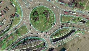
Topographic Survey India
Topographic Survey in India
The business requiring land reviews employ topographic survey agencies to carry out their work. Many land survey companies in India are providing spatial data management covering the area in question. The business owners hire the services of companies that utilize drones for topographic surveys capturing minute details from different angles.
Use of topographic surveys
Topography includes surveying the land and water covering the elevations and other features of an area. These topographies include both natural and human-made structures. A complete picture of the property is given by the inspections done by the unmanned vehicles. An excellent representation of the surface is provided by the surveys so that you can decide how to use the piece most efficiently.
When are topographic surveys needed?
Whenever it is desirable to figure out the land contours on the ground surface slightly above or below the upper layer, the topographic surveys are obligatory. The contractors need a map and design for perimeter boundary lines and zoning to determine the landscapes for construction planning accurately. The information is also required for setbacks, and these surveys need to be done correctly otherwise the same will prove expensive later.
While planning, the results of the survey allow you to improve the conditions and remove the issues if any. The reviews determine the success rate of the project. The UAV photogrammetry and LIDAR define the contours on the surface of a large surface while RTK GPS allows quick mapping for open areas.
The government agencies require the surveys to construct new homes, roads, bridges, driveways, grading, dams, drainage projects and more. The success is depending upon planning which in turn is dependent on results of the topographic analysis.
Why choose PIGEONIS for Topographic Survey
Pigeon Innovative Solutions has experience of several years in conducting topographic land surveys. We make use of drone inspections to collect useful data and process the information to provide accurate results. We have a team of experts to do successful surveys by accumulating data and performing calculations. The results are reliable for agriculture, construction, water storage, environmental mapping and more. Our staff takes out innovative solutions for clients requiring geospatial way outs.
Visit us to expand your business to reach new heights!
Click here to view our service for Smart Farming Solution