
What are Contour lines?
Contour lines are generated by connecting all the points of similar elevation together. These lines are drawn on a plan of a particular terrain to understand the nature of surface, identify cut fill volume, study water flow characteristics, estimate valley depth and steepness. Contour lines form a smooth curve of same elevation points. Contour lines are also called as isohypse, isoline, isopleth, or isarithm.
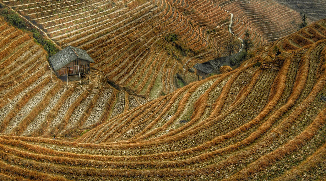
Contour maps are generated of Hill Ranges, Valleys, Mountains, Large lands, Agricultural fields, Farmlands, Forests, Archaeological sites, Water bodies, etc.
What does contour lines indicate?
- -: Widely spaced contour lines indicates flat terrain
- -: Closely spaced contour lines indicates steep terrain
- -: Irregular contour lines indicate uneven surface
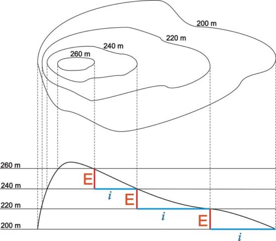
- -: Concentric closed contour lines with increasing values towards center indicates a hill or elevated terrain
- -: Concentric closed contour lines with decreasing values towards center indicates a pond or water body
- -: Contour lines with U-shape convexity indicates ridge
- -: Contour lines with V-shaped convexity indicates valley
- -: When contour lines cross each other, it indicates existence of overhanging cliffs or a cave
- -: When contour lines are meeting in some portion, it indicates existence of a vertical cliff
What are the uses of Contour lines?
Contour lines are generally used to understand the terrain profile for multiple uses as follows:
- -: Depth of cutting and filling is decided from a contour map profile path, when desired level or elevation of road/railway is known
- -: Minimizing and balancing earthworks by deciding the routes of the railway, road, canal or sewer lines using contour lines
- -: Catchment area and quantity of water flow at any point of nalla or river is found out using contour lines
- -: In agricultural work, contours maps are useful as guide lines in planning of trees on hilly terrain and also land improvement project. In addition to this, drainage system is also conveniently planned with contour maps
- -: Initial feasibility study for Wind power or Solar Power project, for studying the terrain profile
- -: Initial feasibility study for Ropeway construction, a survey needs to be done to analyse the terrain for desired ropeway, cable car path
- -: Volumetric calculations are performed as required for extracting the volume of rocks, gravel of a mountain and estimate it’s total value. Hence, Effective Cost estimates is made available with the help of the contour maps
- -: Contour lines are also benificial for Mining companies especially for calculating the volume of stocks
- -: Archaeological surveyors are using contour lines to get insights about history
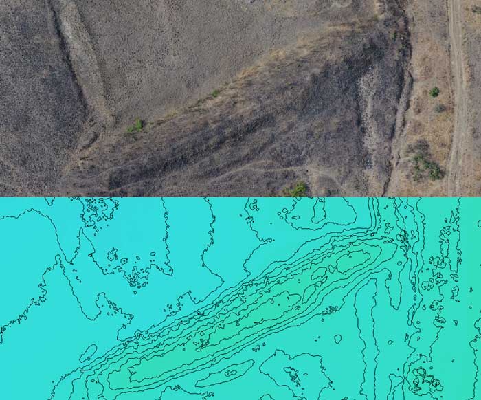
Figure: Contour line of small elevated area
How are contour lines made using Unmanned Aerial Vehicle (UAV) or Drone?
Drones are used to collect the data in the form of High quality images. The complete captured data is aligned by aerial triangulation. The aligned data is then ortho-rectified and georeferenced using the GCP information. Subsequently, the final Digital Elevation Model (DEM) and Contour lines at required elevation change are generated.
Want to carry out contour line survey at your site? Call Pigeonis at +91-9004329048 or rather just drop your requirements at contact@pigeonis.in
An impressive share! I’ve just forwarded this onto a co-worker who was doing a little homework on this. And he actually bought me dinner because I found it for him… lol. So let me reword this…. Thank YOU for the meal!! But yeah, thanks for spending the time to discuss this topic here on your site.
Good article! We will be linking to this great article on our website. Keep up the good writing.
It’s very effortless to find out any matter on net as compared to textbooks, as I found this paragraph at this web page.
I truly treasure your piece of work, Great post.
I appreciate you sharing this blog article.Really thank you! Will read on…
A round of applause for your article post.Much thanks again. Want more.
Your style is unique in comparison to other people I have read stuff from. Thank you for posting when you have the opportunity, Guess I’ll just bookmark this web site.
Pretty! This has been an extremely wonderful article. Thanks for supplying this info.
I loved your article.Really looking forward to read more. Great.
Enjoyed reading through this, very good stuff, thankyou . “All things are difficult before they are easy.” by John Norley.
Looking forward to reading more. Great article. Really Great.
Im grateful for the blog article.Thanks Again. Will read on…
Terrific work! This is the type of info that should be shared around the net. Shame on the search engines for not positioning this post higher! Come on over and visit my site . Thanks =)
Great blog you have here but I was curious if you knew of any user discussion forums that cover the same topics talked about here? I’d really love to be a part of online community where I can get suggestions from other knowledgeable individuals that share the same interest. If you have any recommendations, please let me know. Thanks a lot!
A well-written blog with thorough explanations of the topics. This blog was interesting to read. Thank you for sharing this site; it is fantastic.