
LiDAR technology transforms way of operating drones, offering new possibilities in various fields. From mapping to environmental monitoring, LIDAR-equipped drones are making a significant impact.
The inertial labs RESEPI & LiGrip H300 LiDAR laser scanners are known for their high level of accuracy, multi platform compatibility & some other user friendly features.
As LIDAR technology evolves there is increase in usage of LiDAR sensors in surveying. It’s integration with drones continues to expand. This article explores the fascinating world of LIDAR in drones, highlighting its benefits and applications.
What is LiDAR? Understanding the Basics
LIDAR is used to describe Light Detection and Ranging. This sensor emits light in the form of a pulsed laser to measure distances.
LiDAR technology works by sending out rapid pulses of laser light and recording how long they take to return after hitting a surface. By combining this timing data with other measurements, it produces highly accurate 3D representations of the Earth’s surface.
Key components of a LiDAR system include:
- Pulsed Laser – Emits short bursts of light toward the target area.
- GPS Receiver – Delivers precise geographic positioning.
- Inertial Measurement Unit (IMU) – Maintains stability and tracks orientation during data capture.
By firing millions of pulses each second and detecting their reflections, LiDAR can map landscapes in fine detail, revealing accurate topographical features.
This technology is not only about distance measurement, but it also helps in creating high-resolution digital maps. These maps serve various industries, from construction to environmental monitoring.
How LIDAR Works in Drones?
LIDAR technology, integrated into drones, transforms them into powerful data collection tools. The system, mounted on a drone, scans the surface below with laser pulses
When these laser pulses hit a surface, they reflect back to the drone’s sensor. This reflection allows for the calculation of precise distance and elevation. Drones with LiDAR systems constantly move as they collect data. This Motion enables comprehensive coverage of large areas.
LiDAR sensors and its usage
Surface Mapping: Creates 3D maps.
Vegetation Analysis: Measures forest canopies.
Elevation Data: Provides detailed topography.
Using these functions, LiDAR-equipped drones can capture a large volume of information quickly and efficiently. Moreover, the integration with GPS and IMUs enhances data precision.
Thus, LIDAR drones enhance efficiency in surveying, environmental, and agricultural applications, significantly reducing labor and time costs.
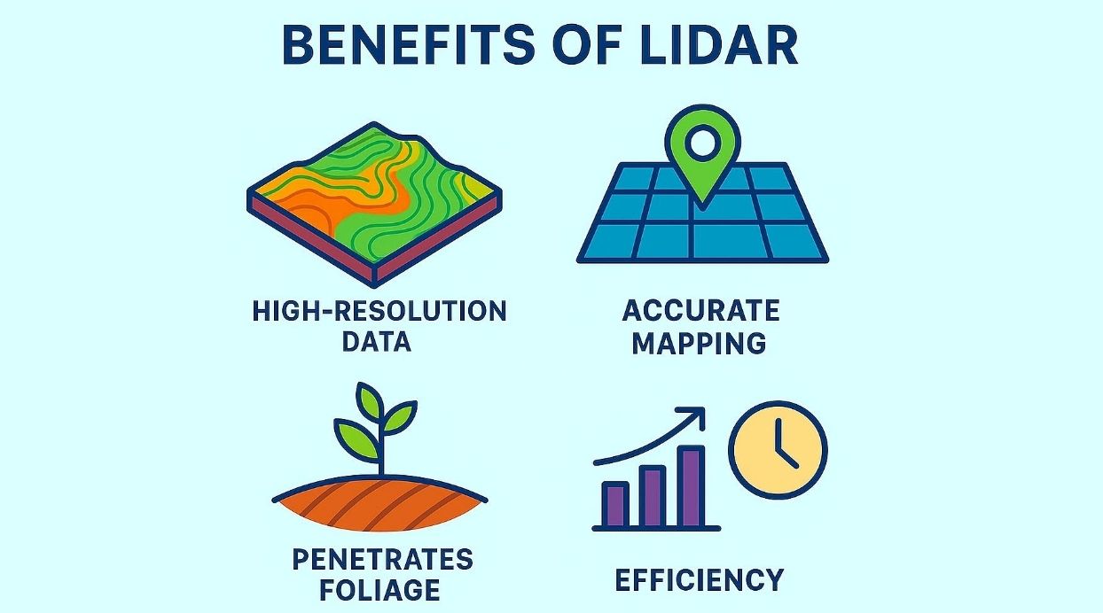
Key Benefits of LiDAR-Enabled Drones
LiDAR-equipped drones bring a range of advantages that surpass conventional surveying techniques. Their capability to produce highly detailed, three-dimensional maps sets them apart in accuracy and reliability.
They also deliver remarkable cost and time efficiency—covering vast areas in a fraction of the time and with far less manual effort. Unlike many other tools, these drones can operate effectively in challenging weather and varied environmental conditions.
Major advantages include:
- High Accuracy – Capable of achieving precision down to the centimeter.
- Speed & Efficiency – Collects large volumes of data quickly.
- Adaptability – Suitable for a wide variety of terrains and environments.
Because of these strengths, LiDAR drones have become essential in industries such as agriculture, environmental research, and infrastructure development. With ongoing advancements, their range of uses continues to expand, promising an even greater role in the future.
LIDAR technology finds itself in several types of drones, each designed for specialized tasks. Some are tailored for high-resolution mapping, while others focus on environmental studies.
SOME OF BEST LiDAR SENSORS ARE:
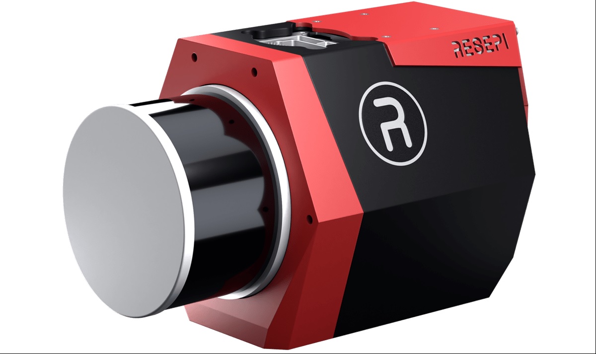
1. LiGrip H300
The LiGrip H300 from Green Valley International is a versatile mapping system that integrates multiple high-precision technologies, including SLAM, PPK-SLAM, and RTK-SLAM, for rapid acquisition of point cloud data with absolute coordinates. It is compatible with LiDAR 360 and LiDAR 360MLS software, providing a complete end-to-end solution for data collection and processing. The system is suitable for a wide range of applications, including detailed mapping, mining surveys, forestry management, and road component inspection. Its combined hardware and software platform ensures efficient, accurate, and reliable results in diverse operational scenarios. The LiGrip H300 streamlines workflows, allowing users to gather, process, and analyze spatial data from a single integrated system.
Features of LiGripH300
- Scan Rate 640,000 pts/s
- Scan Range up to 300 m
- Laser Accuracy up to ± 1 cm
- Multi-Platform Compatibility
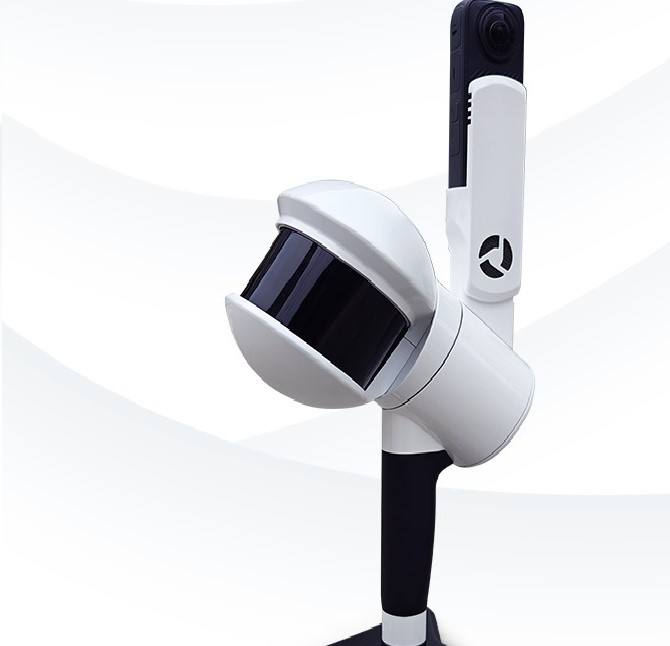
2. Remote Sensing Payload Instrument, or RESEPI
LeRESEPI™ is a modular remote sensing payload integrating GNSS-aided inertial navigation, LiDAR, camera, and communications for real-time and post-processed point cloud generation. It supports major LiDAR brands and includes software for calibration, bore-sighting, and point cloud processing. The compact, customizable platform allows complete assembly, calibration, and post-processing solutions, enabling resellers to focus on market growth.
Features of RESEPI:
- Up to 2 TB USB Memory Drive
- Up to 200 m AGL – Above Ground Level
- 3 – 5 cm Point Cloud Accuracy
- WiFi & GSM Embedded WiFi, Cellular Modem
LiDAR drones are reshaping industries with their unmatched precision in data collection. Their ability to map large areas quickly and accurately makes them essential in surveying, construction, agriculture, and environmental monitoring.
LiDAR sensors and its Usage are:
- Mapping & Surveying – Produces high-resolution topographic maps and digital elevation models, speeding up workflows while reducing manpower.
- Environmental Monitoring – Tracks ecosystem changes, biodiversity patterns, and habitat conditions over time.
- Agriculture – Assesses crop health, predicts yields, and supports resource optimisation.
- Infrastructure Development – Improves planning and construction accuracy with centimetre-level measurements.
The widespread use of LiDAR drones underscores their versatility. Their role in enhancing geospatial data collection is crucial across sectors.
Mapping and Surveying
LIDAR drones are pivotal in mapping and surveying. They deliver accurate, real-time data essential for topographic analysis.
These drones efficiently cover vast areas. They reduce the need for extensive ground surveys, saving resources.
Key features in mapping applications include:
Accuracy: High precision in data collection
Efficiency: Rapid data processing.
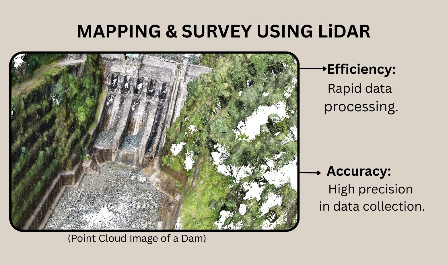
In surveying, LiDAR drones create detailed 3D models. They are key tools for geospatial professionals, streamlining workflows and reducing costs
Environmental and Agriculture Monitoring
LiDAR drones play a crucial role in environmental and agricultural monitoring. They provide details insight into ecosystem dynamics
These drones assess vegetation structure and health. They track environmental changes, aiding in conservation efforts.
In agriculture, they enhance crop management. They offer data to optimize irrigation and predict yields.
Benefits include:
Comprehensive Data: Detailed ecosystem analysis.
Resource Optimization: Improved farming practices.
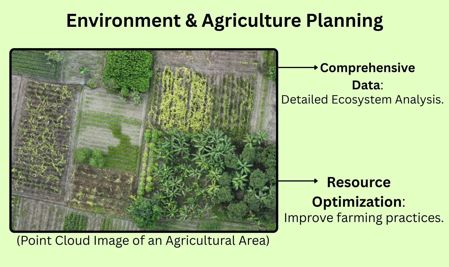
LIDAR drones help monitor forests and farmlands. Their precise data aids in sustainable resource management.
Infrastructure and Urban Planning
Infrastructure and urban planning greatly benefit from LiDAR drones. They offer precise measurements crucial for project success.
Drones create accurate 3D models of construction sites. They assist in monitoring progress and ensuring design adherence.
In urban planning, they map complex cityscapes. They support sustainable development by providing crucial spatial data.
Benefits in this domain include:
Precision: Accurate site measurements.
Sustainability: Supports eco-friendly planning.
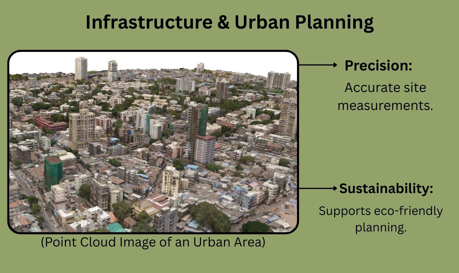
LIDAR drones facilitate informed decision-making. They are vital tools in shaping modern urban environments.
The Future of LiDAR in Drone Technology
LIDAR technology in drones continues to evolve rapidly. Improvements in sensor accuracy and range are on the horizon. These advancements will enhance data quality, vital for various industries.
Integration with artificial intelligence (AI) will streamline data processing. It will enhance ability of LiDAR sensors and increase its usage. This synergy will unlock new possibilities in data analysis. Enhanced real-time capabilities will make drones smarter and more efficient.
Future developments will open up broader applications. Potential expansions include:
Urban Analytics: Smarter city planning strategies.
Environmental Restoration: Improved ecosystem assessment merits
Precision Farming: Tailored agriculture solutions.
As LIDAR technology advances, its role in drone applications will grow. It promises to revolutionize data collection and analysis across different sectors.
Conclusion: The Impact of LiDAR on the Drone Industry
LIDAR technology is reshaping the drone industry. Its ability to provide precise, detailed data is unmatched. This innovation enhances a myriad of applications, from mapping to environmental monitoring.
Drones equipped with LIDAR offer significant advantages. They improve efficiency and reduce the time needed for data collection. These benefits are invaluable in industries like agriculture and urban planning.
As LIDAR continues to evolve, its influence will grow. Future advancements will make drones an even more essential tool. This cutting-edge technology is set to revolutionize industries globally.