
In today’s blog, we are basically going to discuss all the questions regarding the contour survey. All this time we have been talking about drone usage in different things, in different fields, and in different ways. But, today we are going to have a question and answer session where we are going to clear all your doubts regarding the contour survey.
By now we already know it is a drone survey and how drones basically collect information via aerial photography and tell us about the region that is getting surveyed and how the area is and the various different features of the same. So let’s dive into all the possible the questions about contour Survey.
What are Contours?
Before understanding, what is the contour survey we first need to understand what Are contour lines. Accordingly, a contour line, is a line that joins places of similar height. This is basically a diagrammatic representation of how the topography basically is with the help of lines that join places of similar height. Contour lines are also called isotypes, isolines, isopleths, or isarithm.
What Is a Contour Survey?
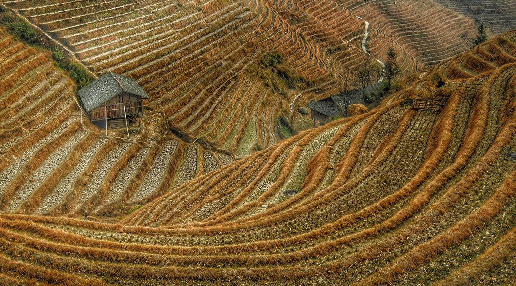
A contour to survey is basically an easy, visually understanding, vertical and horizontal diagrammatic representation of the region that is under survey. By understanding account to the survey that has been conducted, one can understand how low or high the region is. Which part of the region is high or which part of the region is low, will eventually help us understand the flow of water over the property when it rains. It will also help us understand where the water will get collected and where the soil can possibly erode. From a contour survey, one can determine flow models, stream maps, silt traps, maps, etc. A contour survey done by a drone basically helps in analyzing the entire region and provides the proper elevation of each and every point on the ground.
What is easier a registered survey or a contour survey via drone?
Generally, any registered surveyor will take around a week or a few days to basically survey the entire region and will produce the data with the most accuracy with-an error of 5mm. On the contrary, drawn services are an aerial method of scanning the ground, and providing data with maximum accuracy is a little error of 15-25mm. The major constraint that lies in the entire process that differentiates drone service from registered service is that drones always happen faster as compared to the registered ones. Not only is a drone contour survey faster but it is also cheaper as compared to a normally registered survey. While or registered surveyor still collecting data on the ground, the drones have collected the data and have also processed the same in the least available time.
Why are contour surveys so important and what is the best and most precise way to do so?
Both LIDAR and photogrammetry. Aerial contour survey techniques provide a reasonable degree of accuracy. Carrying out either one of them helps in producing better results. Generally, an area with less than 50% vegetation is processed with the help of photogrammetry techniques. While those with more vegetation cover or perform with LIDAR. Contour surveys are important because they help in building and elevation data which is extremely necessary to plan and build construction projects and understand the region.
Contour surveys help in calculating the amount of soil present or the one that needs to be added or removed for a perfect site of the construction plan, and to understand and verify the terraforming of the land that completely fits with the engineered design.
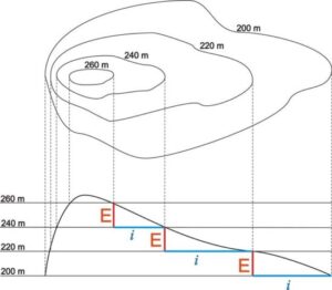
How do you read a contour survey?
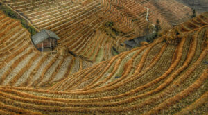
A contour map in serving basically illustrates the elevation differences across the entire region from the lowest point to the highest one. The farther the lines are from each other. The shallow or the rise or fall on the terrain is possible. Contour lines in serving help in denoting the topographic data at the intervals mentioned. For example, a contour map and serving might have intervals down to 0.25 m, but this can be calculated into contours down to 10 cm on lightly undulating lands. Now given below are some major points that need to be taken into consideration while reading a contour survey-
- Widely spaced contour lines indicates flat terrain land contours
- Closely spaced contour lines indicates steep terrain land contours
- Irregular contour lines indicate uneven surface of contour line in contour surveying.
- Concentric closed contour lines with increasing values towards center indicates a hill or elevated terrain
- Concentric closed contour lines with decreasing values towards center indicates a pond or water body
- Contour lines with U-shape convexity indicates ridge in contour mapping
- Contour lines with V-shaped convexity indicates valley in contour mapping
- When contour lines cross each other, it indicates existence of overhanging cliffs or a cave
- When contour lines are meeting in some portion, it indicates existence of a vertical cliff
How do you get a contour mapping in surveying?
Contours help in providing information that helps us study the nature of the terrain and provides accurate information on the selection of the site. It also helps in determining areas of catchment, drainage, basins, flow, models, and inter-visibility between two or more stations.
Let’s understand each and every point in detail.
Contour lines are generally used to understand the terrain profile for multiple uses as follows:
- Depth of cutting and filling is decided from a contour map profile path, when desired level or elevation of road/railway is known in the contour map of surveying.
- Minimizing and balancing earthworks by deciding the routes of the railway, road, canal or sewer lines using contour line in surveying.
- Catchment area and quantity of water flow at any point of drainage areas or river is found out using contour line in surveying.
- In agricultural work, contours maps are useful as guide lines in planning of trees on hilly terrain and also land improvement project. In addition to this, drainage system is also conveniently planned with contour maps
- Initial feasibility study for Wind power or Solar Power project, for studying the terrain profile are extremely necessary in contour line in surveying process.
- Initial feasibility study for Ropeway construction, a contour map in surveying needs to be done to analyze the terrain for desired ropeway, cable car path
- Volumetric calculations are performed as required for extracting the volume of rocks, gravel of a mountain and estimate its total value when a contour map in surveying is generated. Hence, Effective Cost estimates is made available with the help of the contour maps
- Contour lines are also beneficial for Mining companies especially for calculating the volume of stocks
- Archaeological surveyors are using contour lines to get insights about history.
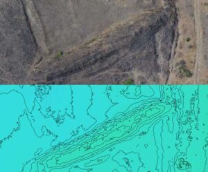
Now contour map in surveying is basically done with the help of drones. Contour line in serving helps in providing data in the form of high-quality images. Drones are generally used to collect such data, and the complete capture data is then aligned by area triangulation. This data is for the orthorectified and geo-referenced using ground control points information. Subsequently, the final data is then processed into creating digital elevation models, digital terrain, models, and contour lines in the survey as required for the elevation is generated.
AUTHOR
– Smruti Sachin Puntambekar
(Data Processing)