LiDAR drones are revolutionising urban landscapes. They are the unsung heroes of smart city development. These drones use Light Detection and Ranging technology. This allows them to create detailed
The Sky Mapper: How LiDAR Drone Survey for smart cities and Infrastructure
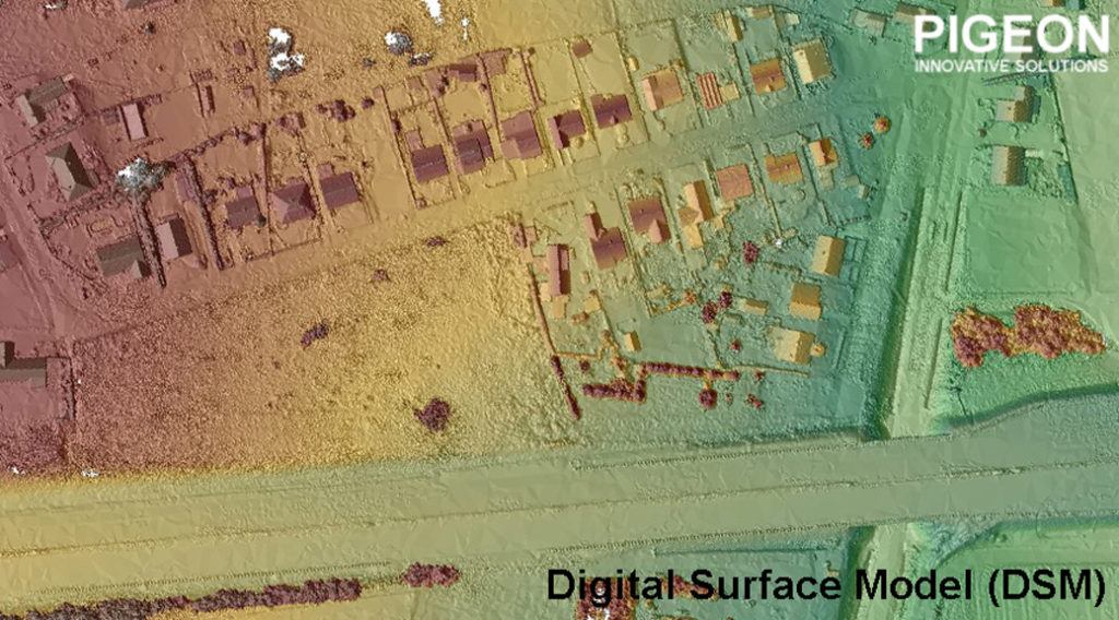
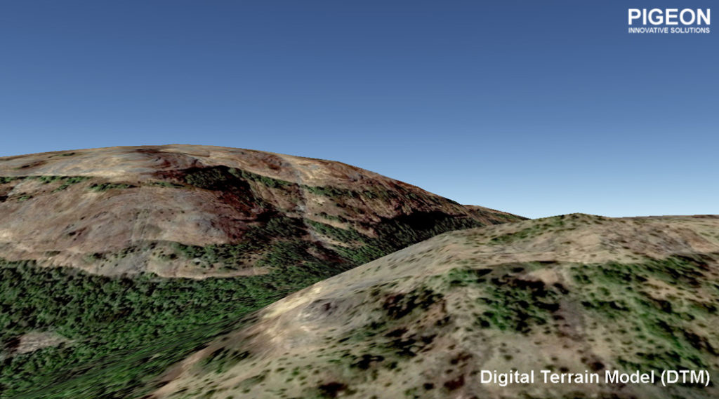
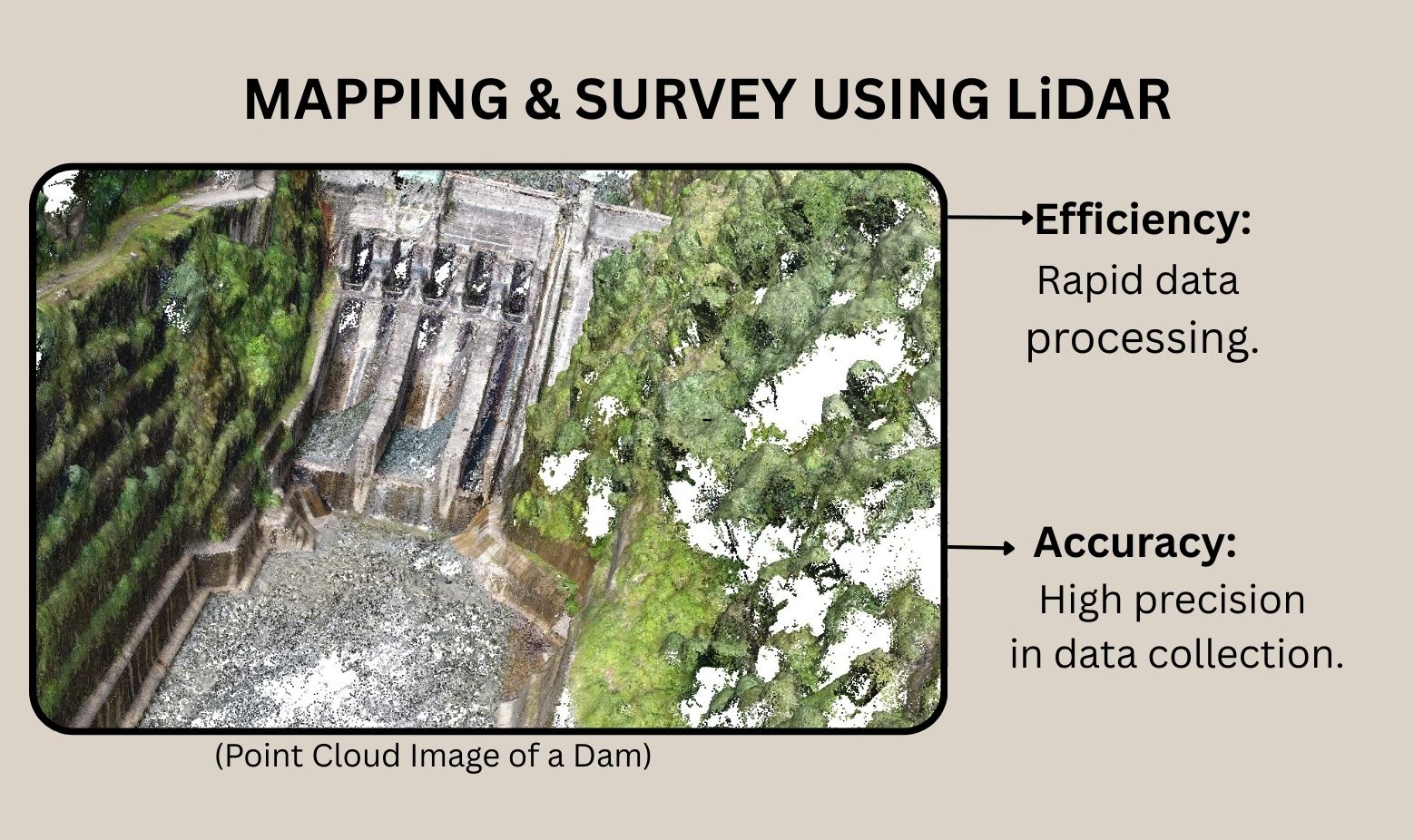
LiDAR drones are revolutionising urban landscapes. They are the unsung heroes of smart city development. These drones use Light Detection and Ranging technology. This allows them to create detailed 3D maps of urban areas. The precision of LiDAR systems is unmatched. They provide crucial data for urban planning and infrastructure. Autonomous drones equipped with LiDAR sensors can operate in challenging environments. They gather data quickly and efficiently. As cities grow, the role of LiDAR drones becomes more vital. They are key to building sustainable and smart urban environments. [caption id="attachment_1834" align="aligncenter" width="720"] point cloud image of a urban area[/caption] What is LiDAR Technology? Understanding the Basics LiDAR is an acronym. It stands for Light Detection and Ranging. It uses laser light to measure distances. A LiDAR system emits laser pulses. These pulses bounce back from surfaces to the sensor. The time taken for this round trip tells the distance. By knowing these distances, LiDAR creates precise 3D images. This is essential for mapping and modelling landscapes and structures. Key features of LiDAR technology include: • High precision in distance measurement • Ability to map large areas quickly • Capable of operating in various weather conditions The data it provides is accurate and invaluable. It is shaping the future of smart city development through reliable insights. How LiDAR Drones Work: The Science Behind the Sky Mapper LiDAR drones combine sophisticated technologies. They use laser pulses to scan the environment. This data creates detailed 3D maps, crucial for smart cities. The drone itself is autonomous. It navigates using GPS and onboard sensors. This allows it to cover expansive areas with little human control. LiDAR sensors are the heart of these drones. They emit rapid laser bursts. Each pulse reflects data about the landscape. Key elements of LiDAR drones include: • Autonomous navigation systems • High-resolution LiDAR sensors • The capability to adapt to different terrains Through this synergy, LiDAR drones enhance urban planning. They offer smart solutions for mapping, monitoring, and managing urban spaces. Their ability to function independently in challenging environments makes them indispensable tools. Key Components: LiDAR System, LiDAR Sensor, and Autonomous Drones At the core of every LiDAR drone is the LiDAR system. This system uses Light Detection and Ranging to measure distances. It enables precise data collection necessary for 3D mapping and urban modelling. LiDAR sensors are specialised components of this system. They emit and receive laser pulses. This action helps in capturing intricate details of landscapes and infrastructure. Autonomous drones integrate these technologies seamlessly. They utilise advanced navigation to operate independently. This capability is essential for efficiency and accuracy in data acquisition. [caption id="attachment_1836" align="aligncenter" width="720"]
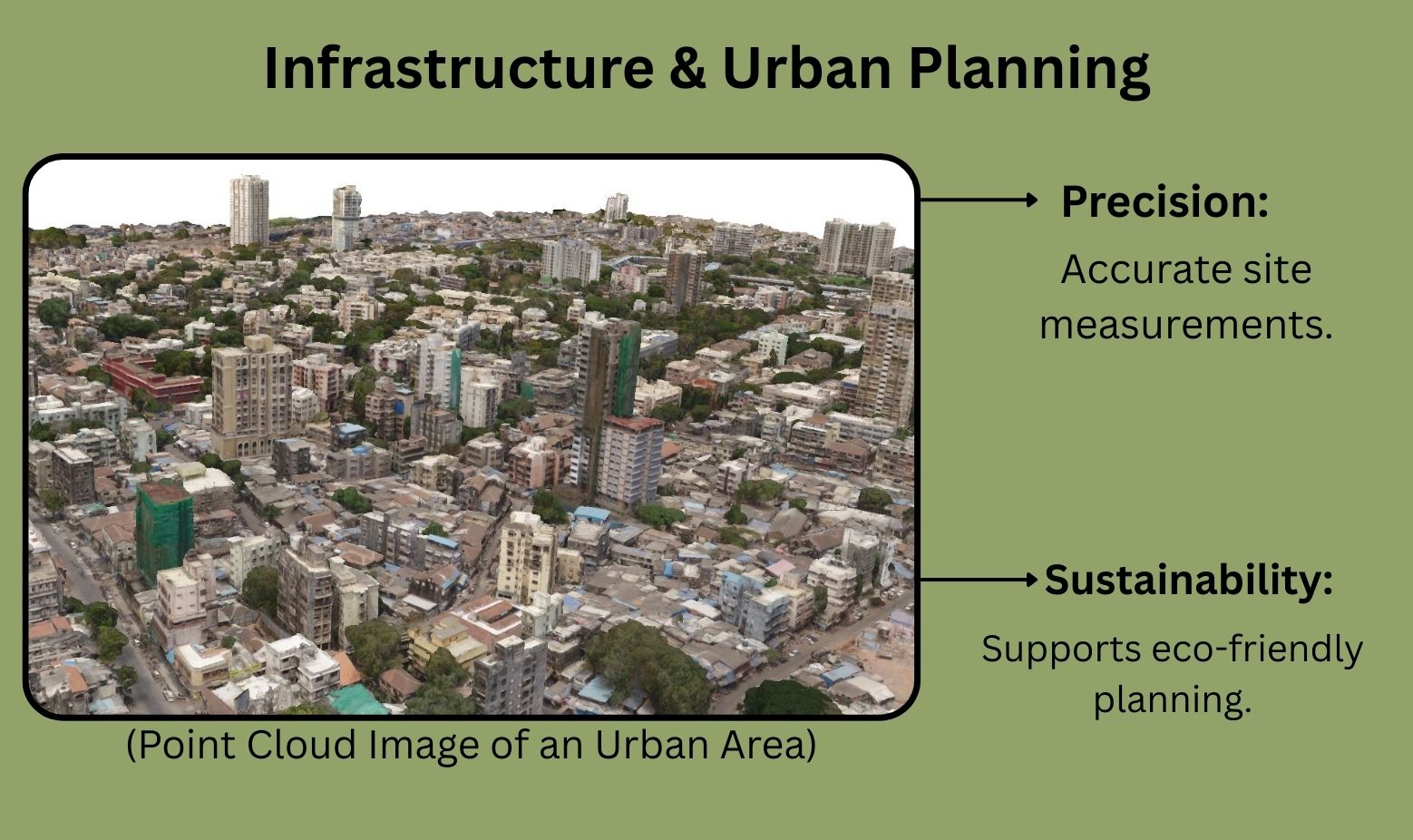
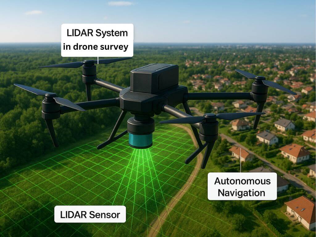 key components of lidar sensors[/caption] Key components of a LiDAR drone include: • The LiDAR system for data collection • LiDAR sensors for laser pulse emission • Autonomous navigation systems for self-operation By working together, these components enable drones to revolutionise smart city development and infrastructure management. The Role of LiDAR Drones for Smart City Survey LiDAR drones are crucial in survey for smart cities. They provide detailed topographical maps, aiding in precise urban planning. These maps support the development of infrastructure projects efficiently. Their role extends beyond just mapping. LiDAR drones help monitor urban growth and changes. This ensures sustainable development by identifying areas for improvement or preservation. The integration of LiDAR technology in smart cities promotes safe and secure environments. By delivering real-time data, these drones enhance surveillance and emergency response systems. This contributes to improved public safety. Key roles of LiDAR drones include: • Creating detailed topographical maps • Monitoring urban growth and changes • Enhancing public safety through real-time data Ultimately, these drones enable cities to become smarter and more responsive to the needs of their residents. They help in building resilient and sustainable urban environments. Urban Planning and 3D Mapping: Building the Cities of Tomorrow Urban planning relies heavily on accurate mapping, and LiDAR drones offer a transformative solution. Using LiDAR drone survey for cities, helps to create precise 3D maps. These maps enable planners to visualise and design urban landscapes effectively. 3D mapping with LiDAR assists in sustainable development. It allows for detailed analysis of landscapes, which informs better decision-making. This technology ensures that new developments are environmentally friendly and efficient. One significant advantage of LiDAR is its ability to capture data quickly over large areas. This speed is invaluable in rapidly changing urban environments. It supports planning processes by providing up-to-date information. Applications in urban planning include: • Visualising future developments • Analysing environmental impacts • Supporting sustainable construction projects. With LiDAR drones, urban planners can build efficient, livable cities that are ready for the future. Their ability to provide comprehensive data helps shape cities that are adaptable and resilient. [caption id="attachment_1837" align="aligncenter" width="720"]
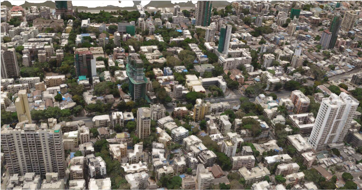 3D model of an urban area[/caption] Infrastructure Inspection and Preventive Maintenance Regular infrastructure inspection is crucial for city safety and maintenance. LiDAR drone survey for cities enhance this process by providing accurate and detailed data. They efficiently inspect bridges, roads, and buildings. LiDAR technology offers significant advantages for preventive maintenance. Detecting structural issues early helps avoid costly repairs. This proactive approach extends the lifespan of infrastructure and ensures public safety. The benefits of using LiDAR drones for city inspection include: • Fast and efficient data collection • Detection of minute structural changes • Reduced need for manual inspections By identifying potential problems early, city officials can address issues before they escalate. LiDAR drones enable cities to maintain their infrastructure effectively. This enhances reliability and safety across urban environments. Traffic, Transportation, and Smart Mobility Solutions [caption id="attachment_1838" align="aligncenter" width="720"]
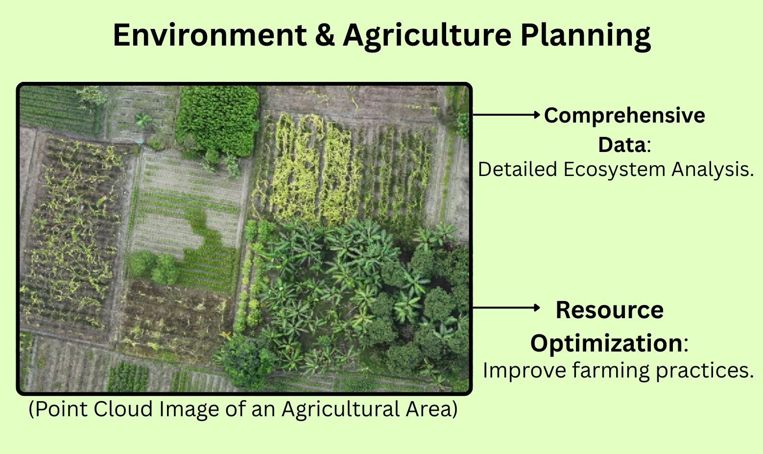
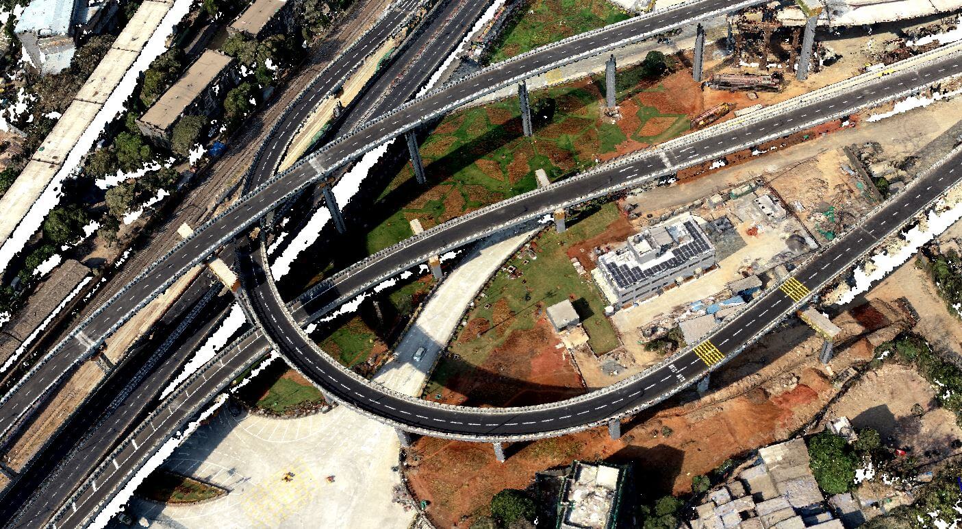 Point cloud image of flyover[/caption] Traffic management is a core challenge for smart cities. LiDAR drone survey provide real-time data, improving road traffic flow and reducing congestion. This enhances the overall efficiency of transportation systems. LiDAR technology plays a pivotal role in smart mobility solutions. By analysing road conditions, it aids in optimising public transport routes. This leads to more predictable and reliable transit schedules. Benefits of LiDAR drone survey in urban transportation include: • Real-time traffic monitoring • Improved route optimisation • Enhanced public transport efficiency The ability of LiDAR drones to gather precise data offers unparalleled insights into road usage patterns. This supports the development of future-ready transportation solutions, ensuring sustainability and efficiency in urban mobility. Environmental Monitoring and Disaster Management LiDAR drones are vital for environmental conservation. They monitor changes in landscapes and assess vegetation health. This aids in ecological preservation and resource management. In disaster scenarios, LiDAR technology provides rapid situational awareness. Accurate mapping of affected areas allows for efficient emergency response. This reduces damage and saves lives by enabling timely interventions. Key benefits of LiDAR drones in this context include: • Precise landscape monitoring • Rapid disaster area mapping • Enhanced emergency response These drones offer valuable insights for both proactive environmental stewardship and reactive disaster management. Their ability to operate in challenging conditions makes them indispensable tools for safeguarding both natural and urban environments. Security, Surveillance, and Public Safety in Smart Cities LiDAR drone survey for cities play a vital role in enhancing security and safety. They provide real-time monitoring, ensuring rapid identification of potential threats. This improves overall city safety. The accuracy of LiDAR technology allows for detailed surveillance in various environments. It is effective in both wide-open spaces and densely populated areas. This flexibility is essential for comprehensive public safety strategies. Key uses of LiDAR drone surveillance for cities include: • Real-time threat detection • Detailed surveillance capabilities • Rapid response facilitation By integrating LiDAR systems into city infrastructure, we can boost security measures and contribute to safer urban living. Integrating LiDAR Data with IoT and Smart City Platforms Integrating LiDAR data into IoT systems transforms how smart cities operate. It allows for seamless data sharing and analysis. This integration enhances the efficiency of urban management processes. The combination of LiDAR with smart city platforms offers numerous benefits: • Improved infrastructure management • Enhanced environmental monitoring • Optimised resource allocation By merging LiDAR technology with IoT, cities can better manage resources, improve services, and enhance urban living standards. Real-World Examples: LiDAR Drones in Action LiDAR drones are proving invaluable around the world. In Tokyo, they aid in disaster response by providing real-time terrain data post-earthquake. This rapid assessment is crucial for effective extrication operations. In New York City, LiDAR drones help manage and maintain ageing infrastructure. They offer detailed inspections of bridges, tunnels, and roads without disrupting traffic. This early detection of potential issues prevents costly repairs. Consider some instances where LiDAR drones shine: • Urban planning in singapore using drones • Flood risk analysis in Venice • Wildlife habitat monitoring in the Amazon These examples highlight the transformative impact of LiDAR drones in smart city applications. Challenges and Future Trends in LiDAR Drone Technology LiDAR drone technology faces several challenges despite its benefits. Moreover, regulatory hurdles can slow down deployment, especially in urban areas. Looking to the future, advancements are promising: • Reduced costs through improved manufacturing. • Enhanced sensor accuracy for better mapping. • Greater integration with AI for autonomous operations. These trends indicate a bright future for LiDAR drones in smart cities. As technology evolves, LiDAR drones will become more accessible and efficient, playing a pivotal role in urban development. Conclusion: The Future of LiDAR Drones for Smart Cities LiDAR drones are transforming urban landscapes through precision and efficiency. Their role in creating smart cities grows as technology evolves further. The potential applications are vast and exciting. Embracing LiDAR technology today sets the stage for innovative, resilient urban environments tomorrow. As cities adapt to modern challenges, LiDAR drones stand at the forefront of this transformation.
point cloud image of a urban area[/caption] What is LiDAR Technology? Understanding the Basics LiDAR is an acronym. It stands for Light Detection and Ranging. It uses laser light to measure distances. A LiDAR system emits laser pulses. These pulses bounce back from surfaces to the sensor. The time taken for this round trip tells the distance. By knowing these distances, LiDAR creates precise 3D images. This is essential for mapping and modelling landscapes and structures. Key features of LiDAR technology include: • High precision in distance measurement • Ability to map large areas quickly • Capable of operating in various weather conditions The data it provides is accurate and invaluable. It is shaping the future of smart city development through reliable insights. How LiDAR Drones Work: The Science Behind the Sky Mapper LiDAR drones combine sophisticated technologies. They use laser pulses to scan the environment. This data creates detailed 3D maps, crucial for smart cities. The drone itself is autonomous. It navigates using GPS and onboard sensors. This allows it to cover expansive areas with little human control. LiDAR sensors are the heart of these drones. They emit rapid laser bursts. Each pulse reflects data about the landscape. Key elements of LiDAR drones include: • Autonomous navigation systems • High-resolution LiDAR sensors • The capability to adapt to different terrains Through this synergy, LiDAR drones enhance urban planning. They offer smart solutions for mapping, monitoring, and managing urban spaces. Their ability to function independently in challenging environments makes them indispensable tools. Key Components: LiDAR System, LiDAR Sensor, and Autonomous Drones At the core of every LiDAR drone is the LiDAR system. This system uses Light Detection and Ranging to measure distances. It enables precise data collection necessary for 3D mapping and urban modelling. LiDAR sensors are specialised components of this system. They emit and receive laser pulses. This action helps in capturing intricate details of landscapes and infrastructure. Autonomous drones integrate these technologies seamlessly. They utilise advanced navigation to operate independently. This capability is essential for efficiency and accuracy in data acquisition. [caption id="attachment_1836" align="aligncenter" width="720"] key components of lidar sensors[/caption] Key components of a LiDAR drone include: • The LiDAR system for data collection • LiDAR sensors for laser pulse emission • Autonomous navigation systems for self-operation By working together, these components enable drones to revolutionise smart city development and infrastructure management. The Role of LiDAR Drones for Smart City Survey LiDAR drones are crucial in survey for smart cities. They provide detailed topographical maps, aiding in precise urban planning. These maps support the development of infrastructure projects efficiently. Their role extends beyond just mapping. LiDAR drones help monitor urban growth and changes. This ensures sustainable development by identifying areas for improvement or preservation. The integration of LiDAR technology in smart cities promotes safe and secure environments. By delivering real-time data, these drones enhance surveillance and emergency response systems. This contributes to improved public safety. Key roles of LiDAR drones include: • Creating detailed topographical maps • Monitoring urban growth and changes • Enhancing public safety through real-time data Ultimately, these drones enable cities to become smarter and more responsive to the needs of their residents. They help in building resilient and sustainable urban environments. Urban Planning and 3D Mapping: Building the Cities of Tomorrow Urban planning relies heavily on accurate mapping, and LiDAR drones offer a transformative solution. Using LiDAR drone survey for cities, helps to create precise 3D maps. These maps enable planners to visualise and design urban landscapes effectively. 3D mapping with LiDAR assists in sustainable development. It allows for detailed analysis of landscapes, which informs better decision-making. This technology ensures that new developments are environmentally friendly and efficient. One significant advantage of LiDAR is its ability to capture data quickly over large areas. This speed is invaluable in rapidly changing urban environments. It supports planning processes by providing up-to-date information. Applications in urban planning include: • Visualising future developments • Analysing environmental impacts • Supporting sustainable construction projects. With LiDAR drones, urban planners can build efficient, livable cities that are ready for the future. Their ability to provide comprehensive data helps shape cities that are adaptable and resilient. [caption id="attachment_1837" align="aligncenter" width="720"] 3D model of an urban area[/caption] Infrastructure Inspection and Preventive Maintenance Regular infrastructure inspection is crucial for city safety and maintenance. LiDAR drone survey for cities enhance this process by providing accurate and detailed data. They efficiently inspect bridges, roads, and buildings. LiDAR technology offers significant advantages for preventive maintenance. Detecting structural issues early helps avoid costly repairs. This proactive approach extends the lifespan of infrastructure and ensures public safety. The benefits of using LiDAR drones for city inspection include: • Fast and efficient data collection • Detection of minute structural changes • Reduced need for manual inspections By identifying potential problems early, city officials can address issues before they escalate. LiDAR drones enable cities to maintain their infrastructure effectively. This enhances reliability and safety across urban environments. Traffic, Transportation, and Smart Mobility Solutions [caption id="attachment_1838" align="aligncenter" width="720"] Point cloud image of flyover[/caption] Traffic management is a core challenge for smart cities. LiDAR drone survey provide real-time data, improving road traffic flow and reducing congestion. This enhances the overall efficiency of transportation systems. LiDAR technology plays a pivotal role in smart mobility solutions. By analysing road conditions, it aids in optimising public transport routes. This leads to more predictable and reliable transit schedules. Benefits of LiDAR drone survey in urban transportation include: • Real-time traffic monitoring • Improved route optimisation • Enhanced public transport efficiency The ability of LiDAR drones to gather precise data offers unparalleled insights into road usage patterns. This supports the development of future-ready transportation solutions, ensuring sustainability and efficiency in urban mobility. Environmental Monitoring and Disaster Management LiDAR drones are vital for environmental conservation. They monitor changes in landscapes and assess vegetation health. This aids in ecological preservation and resource management. In disaster scenarios, LiDAR technology provides rapid situational awareness. Accurate mapping of affected areas allows for efficient emergency response. This reduces damage and saves lives by enabling timely interventions. Key benefits of LiDAR drones in this context include: • Precise landscape monitoring • Rapid disaster area mapping • Enhanced emergency response These drones offer valuable insights for both proactive environmental stewardship and reactive disaster management. Their ability to operate in challenging conditions makes them indispensable tools for safeguarding both natural and urban environments. Security, Surveillance, and Public Safety in Smart Cities LiDAR drone survey for cities play a vital role in enhancing security and safety. They provide real-time monitoring, ensuring rapid identification of potential threats. This improves overall city safety. The accuracy of LiDAR technology allows for detailed surveillance in various environments. It is effective in both wide-open spaces and densely populated areas. This flexibility is essential for comprehensive public safety strategies. Key uses of LiDAR drone surveillance for cities include: • Real-time threat detection • Detailed surveillance capabilities • Rapid response facilitation By integrating LiDAR systems into city infrastructure, we can boost security measures and contribute to safer urban living. Integrating LiDAR Data with IoT and Smart City Platforms Integrating LiDAR data into IoT systems transforms how smart cities operate. It allows for seamless data sharing and analysis. This integration enhances the efficiency of urban management processes. The combination of LiDAR with smart city platforms offers numerous benefits: • Improved infrastructure management • Enhanced environmental monitoring • Optimised resource allocation By merging LiDAR technology with IoT, cities can better manage resources, improve services, and enhance urban living standards. Real-World Examples: LiDAR Drones in Action LiDAR drones are proving invaluable around the world. In Tokyo, they aid in disaster response by providing real-time terrain data post-earthquake. This rapid assessment is crucial for effective extrication operations. In New York City, LiDAR drones help manage and maintain ageing infrastructure. They offer detailed inspections of bridges, tunnels, and roads without disrupting traffic. This early detection of potential issues prevents costly repairs. Consider some instances where LiDAR drones shine: • Urban planning in singapore using drones • Flood risk analysis in Venice • Wildlife habitat monitoring in the Amazon These examples highlight the transformative impact of LiDAR drones in smart city applications. Challenges and Future Trends in LiDAR Drone Technology LiDAR drone technology faces several challenges despite its benefits. Moreover, regulatory hurdles can slow down deployment, especially in urban areas. Looking to the future, advancements are promising: • Reduced costs through improved manufacturing. • Enhanced sensor accuracy for better mapping. • Greater integration with AI for autonomous operations. These trends indicate a bright future for LiDAR drones in smart cities. As technology evolves, LiDAR drones will become more accessible and efficient, playing a pivotal role in urban development. Conclusion: The Future of LiDAR Drones for Smart Cities LiDAR drones are transforming urban landscapes through precision and efficiency. Their role in creating smart cities grows as technology evolves further. The potential applications are vast and exciting. Embracing LiDAR technology today sets the stage for innovative, resilient urban environments tomorrow. As cities adapt to modern challenges, LiDAR drones stand at the forefront of this transformation.
 terrestrial lidar vs lidar drone[/caption] This integration is particularly valuable for sectors like infrastructure development, forestry, and environmental conservation, where accurate spatial data directly impacts planning and decision-making.
  benefits of using lidar drone in surveying[/caption]
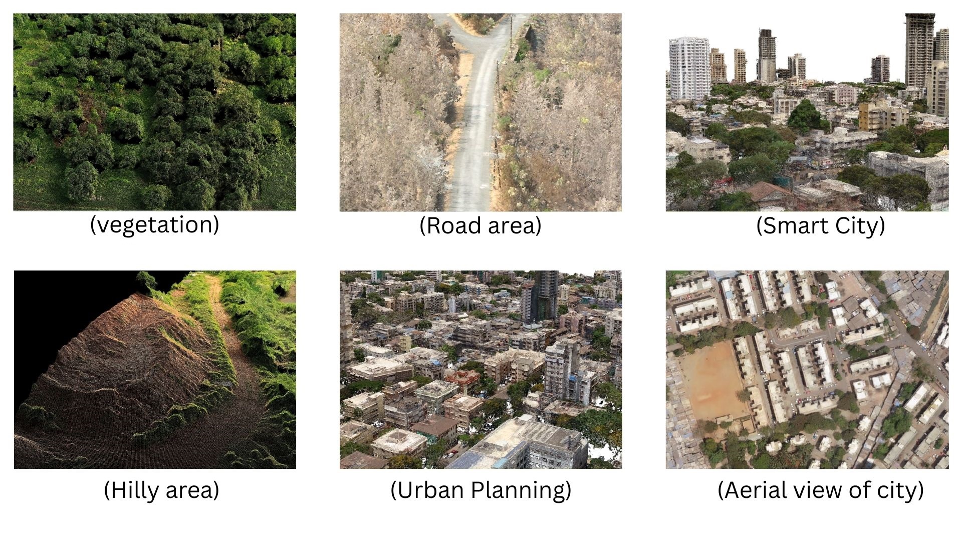
 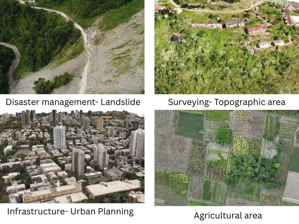 collage of drone survey in different areas[/caption]
 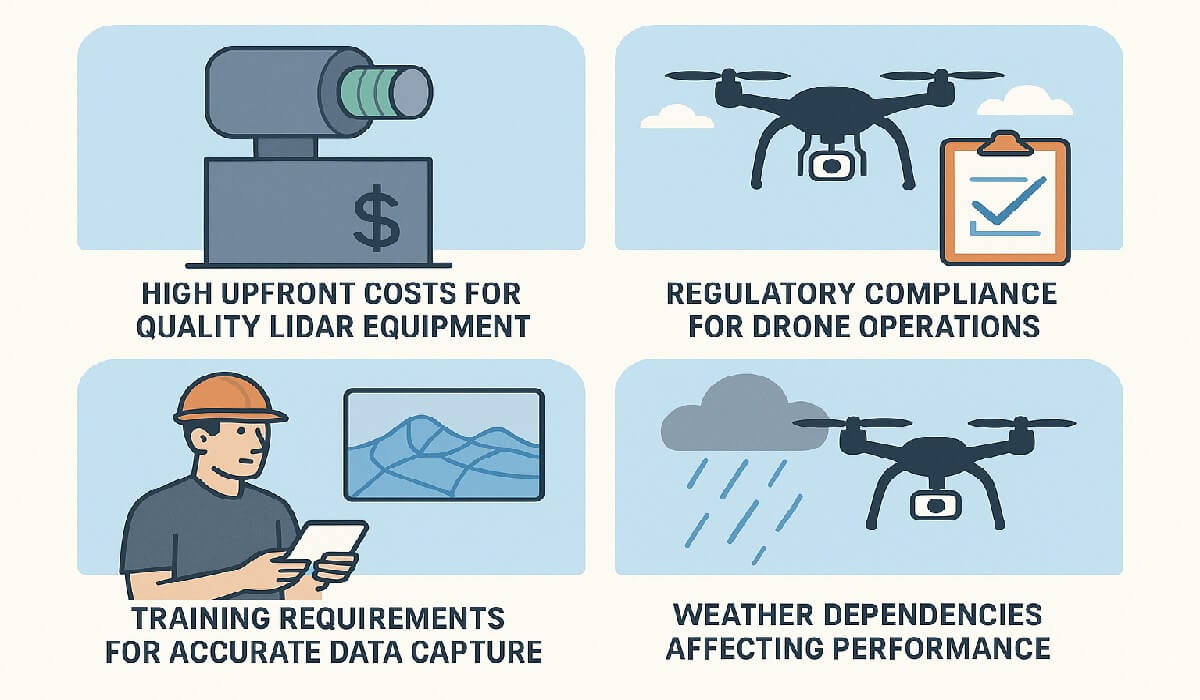 challenges in lidar drone survey[/caption]
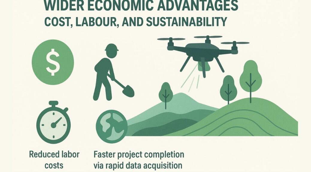
 Collage of lidar in multiple industries[/caption] Understanding "LiDAR Technology" is crucial for grasping its potential. As it integrates with drones, its impact on industries becomes even more profound.
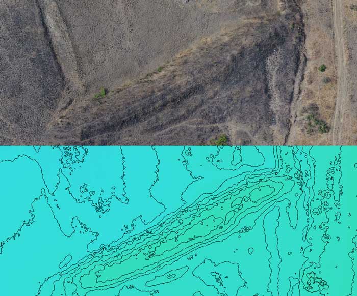
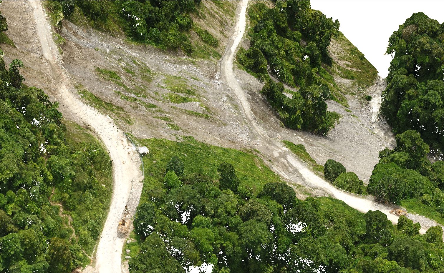 LiDAR based poind cloud of landslide[/caption] One of the driving forces behind this growth is the steady drop in drone costs. As technology becomes more affordable, its accessibility improves, encouraging organizations in multiple sectors to integrate drones into their processes. Market insights point to a strong upward trajectory for the drone industry. Demand is surging as companies leverage drones for improved data gathering, better decision-making, and higher efficiency.
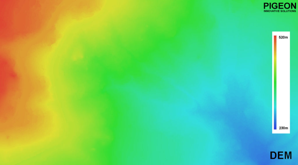
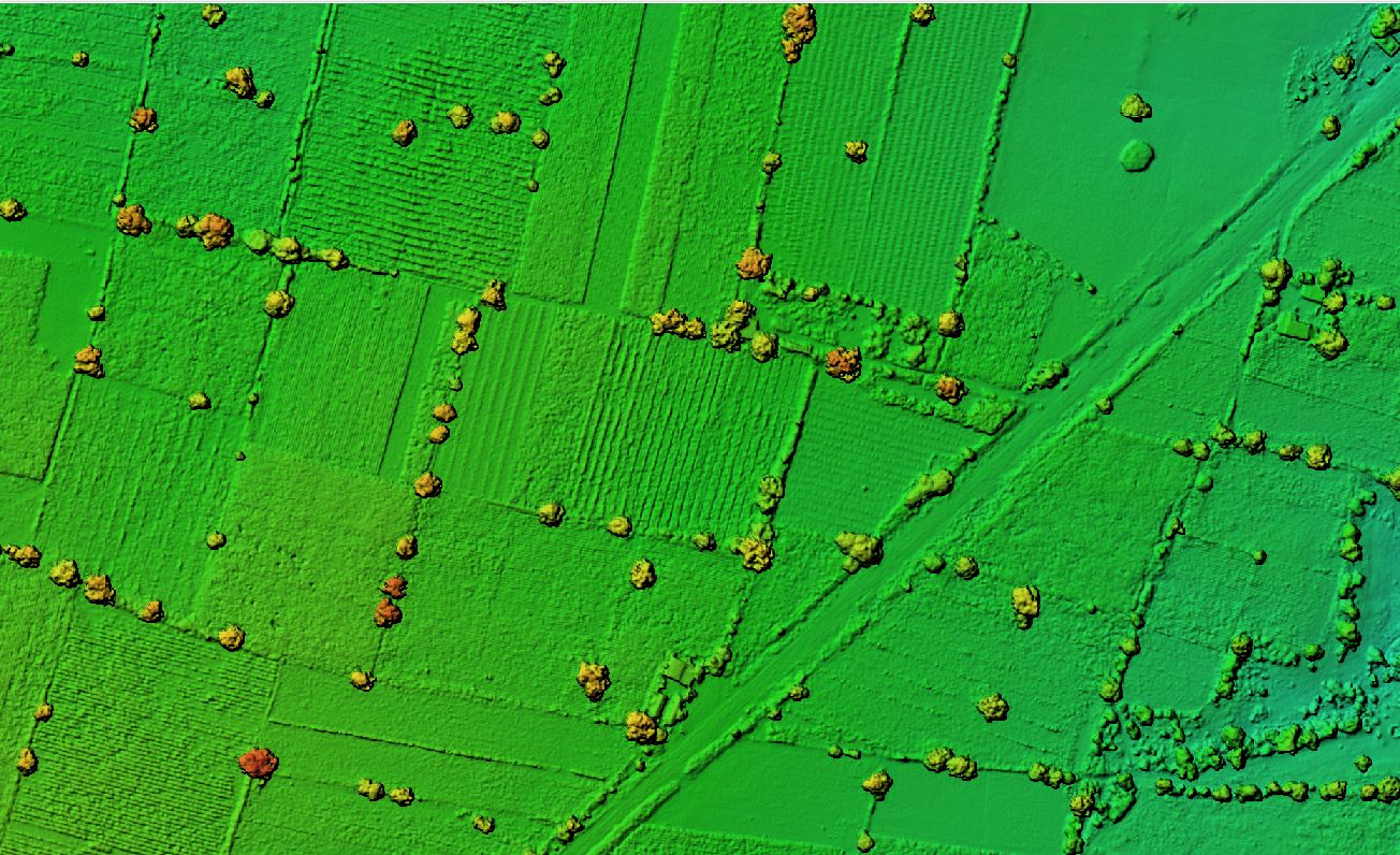 Digital Elevation Model of agricultural land[/caption]
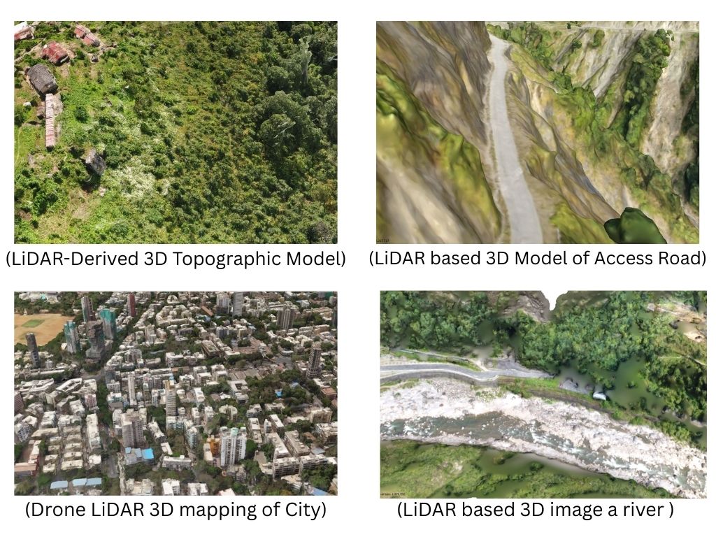
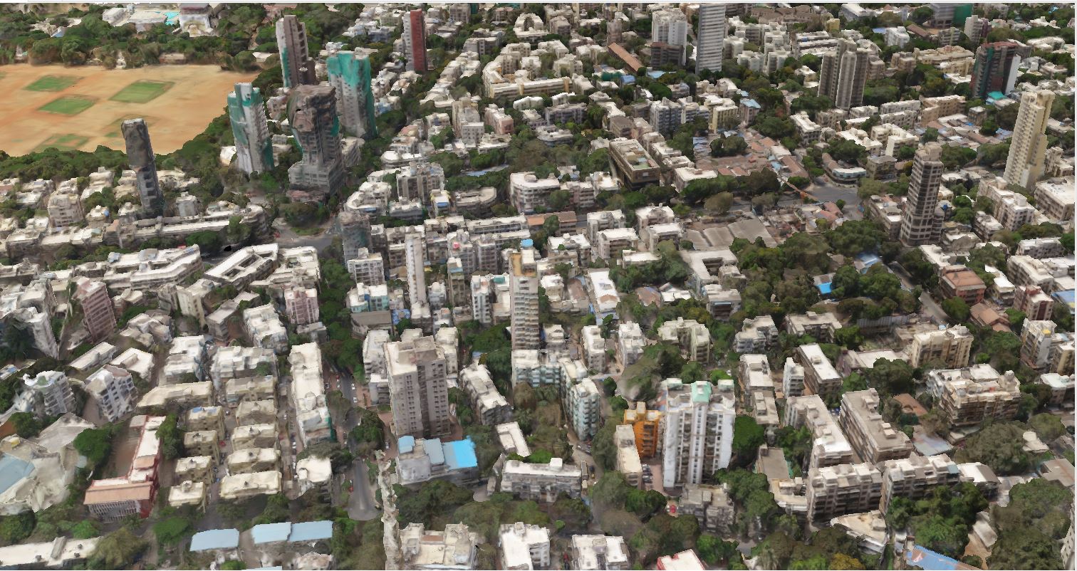 3D model of urban area[/caption]
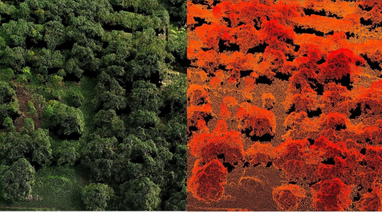 Point Cloud of Dense Vegetation[/caption]
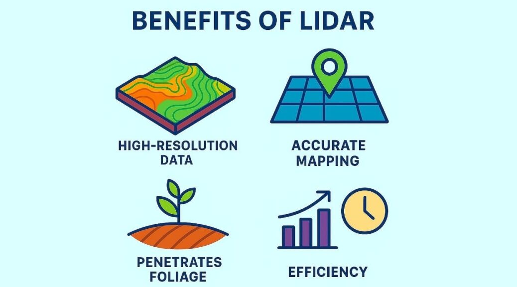
 Usage of LiDAR Drones in multiple industries[/caption]
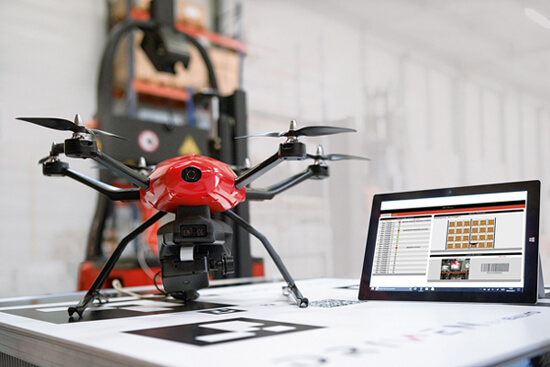
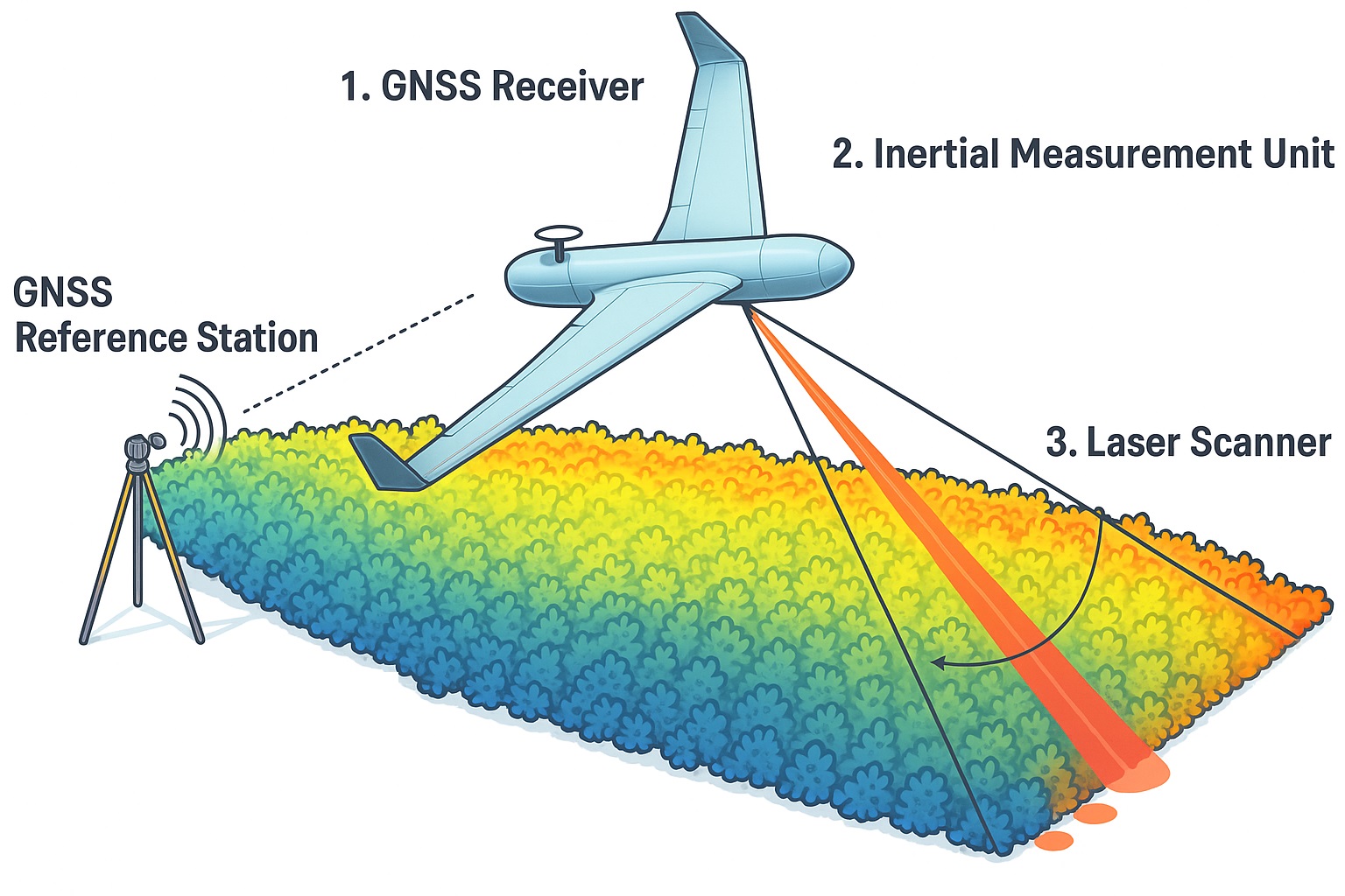 Components of LiDAR Drone[/caption]
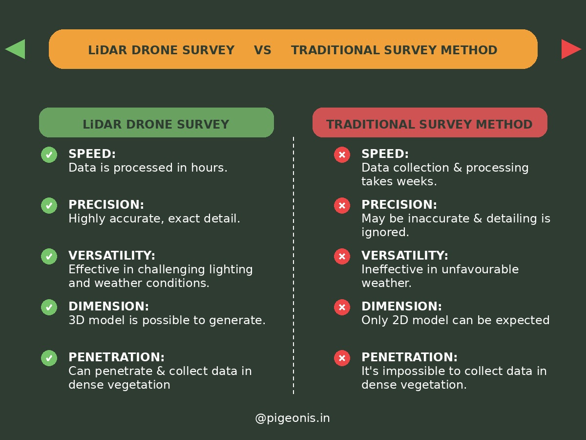 Difference between lidar survey and drone survey[/caption]